EXECUTIVE SUMMARY
Central Kalimantan is at a crucial juncture for sustainable land use. The region is in the middle of a mid-term regional development planning process and has the opportunity to make choices that benefit its communities and businesses into the future. Strong, evidence-based information on land values can inform the Strategic Environmental Assessment which feeds into the provincial spatial plan (Rencana Tata Ruang Wilayah Provinsi or “RTRWP”).
This analysis, the Central Kalimantan: High Conservation Value Provincial Assessment, produced by the Palangka Raya Institute for Land Use and Agricultural Research (PILAR), a center of excellence under the Faculty of Agriculture, University of Palangka Raya, in partnership with Climate Policy Initiative (CPI), provides a framework to help the Central Kalimantan government, businesses and communities make informed decisions about how to manage land more sustainably. In particular, the report identifies biological, ecological, social, and cultural values considered exceptionally important in Central Kalimantan, and identifies threats to areas where these values occur.
Overall, the study finds that Central Kalimantan has significant tracts of high conservation value (HCV) areas, covering more than half of the province. Nearly two thirds of the HCV areas in Central Kalimantan are at risk from various planned development activities. The study also identifies concrete opportunities to mainstream these HCV assessment results into regional policy by integrating HCV into spatial plans and business license processes, or by acknowledging voluntary HCV management efforts conducted by concession holders.
Protected areas and those that support their biodiversity (HCV 1.1) cover nearly 3 million ha and are present in all districts of Central Kalimantan except Barito Timur, are critical to maintain biodiversity. They are largely concentrated in the peat and mixed swamp areas of the south and in a relatively thin strip along the north of the province in the well-drained upland forest areas (bordering West and East Kalimantan).
The large natural landscapes (HCV 2.1) map shows forest blocks with core areas larger than 20,000 ha extending across 3.2 million ha, present in all districts of Central Kalimantan except Sukamara and Barito Timur. These areas are concentrated in: (1) the well-drained upland forest in the north of the province (especially Murung Raya district) and extending westward into mountainous areas (especially Katingan); and (2) mainly peat and mixed swamp areas extending from the center of the province to the south and southeast, including protected areas (especially Katingan, Kapuas and Pulang Pisau).
Transition zones between different major ecosystem types (HCV 2.2) are the most widespread HCV areas in the province. The total area of HCV 2.2 covers slightly more than 4.5 million ha or roughly 30% of the province. HCV 2.2 is especially concentrated in the northern and northeastern part of the province. Three types of HCV 2.2 transitions are mapped: (i) elevational transitions (clines) in mountainous areas of the north, (ii) heath to non-heath throughout the central region and parts of the north; and (iii) swamp to non-swamp transitions throughout central and southern parts of the province.
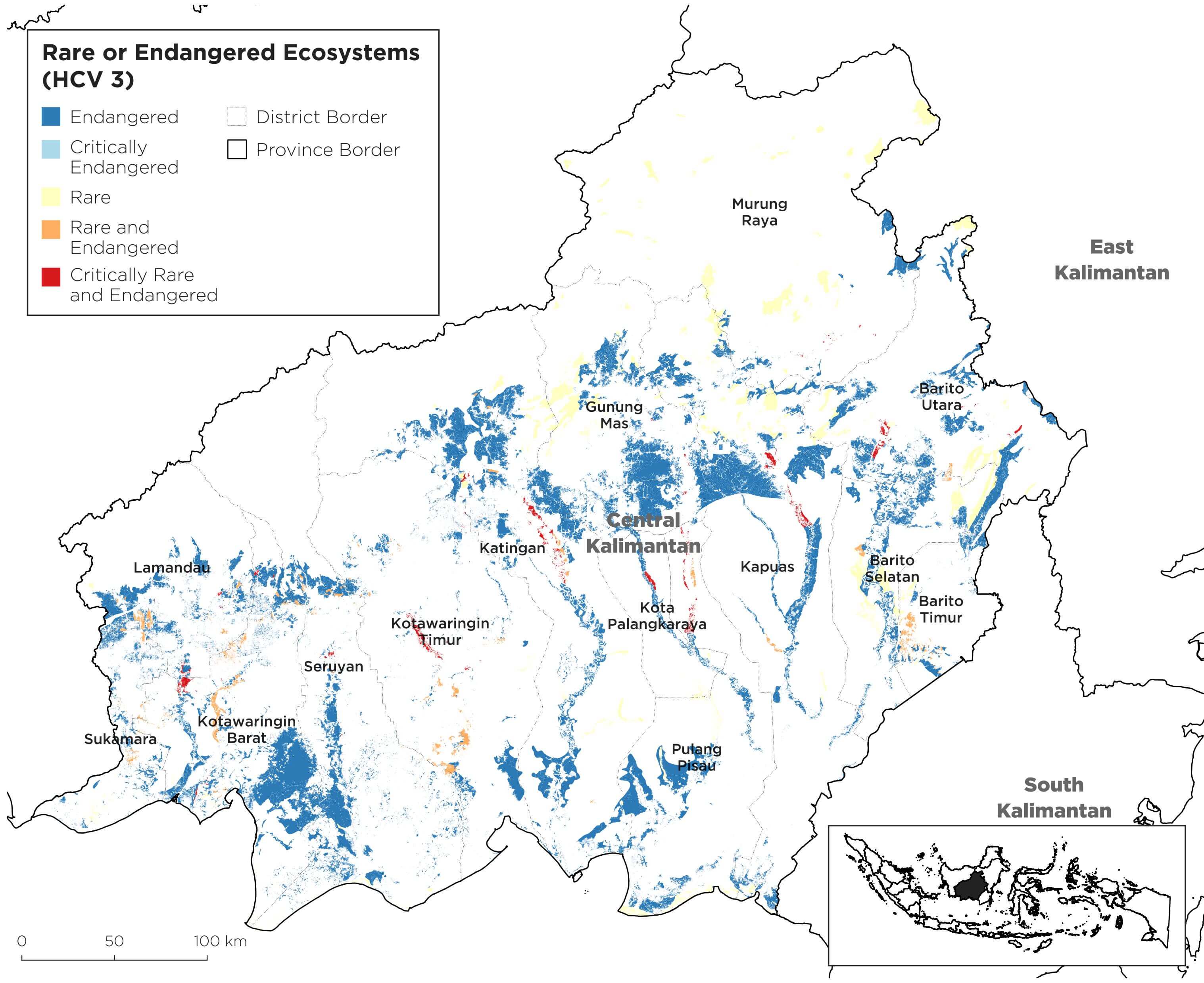
Rare or endangered ecosystems (HCV 3) are less extensive than other HCV areas but present in all districts and cover an estimated 1.73 million ha. They are most extensive in Gunung Mas, Kapuas, and Katingan districts. Significant HCV 3 areas are also present in Seruyan, Kotawaringin Barat, and Barito Utara. In contrast, these areas are more sparse in Murung Raya, where deforestation has been more limited. Endangered ecosystems (purple) are widespread. Critically endangered ecosystems (pink) are found in patches. Rare ecosystems (yellow) occur as strips of alluvial forest along following major rivers. Rare and endangered ecosystems (orange) occur mainly in the southwest. Rare and critically endangered ecosystems (red) are restricted mainly to rare riparian and alluvial zones associated with the major rivers of the province. HCV 3 areas must be prioritized for protection since these ecosystems are already endangered and they are diminishing rapidly.


 High-value natural landscapes are in decline, particularly forests. Forest cover in Central Kalimantan declined by 4 million ha (or by 32%) between 1973-2012, a rate of nearly 100,000 ha per annum. This change in forest cover was related to a surge of extractive industrial activities starting in the early 1970s. In 2012, remaining forest area was just over 8.1 million ha, equivalent to nearly 50% of the provincial area. Levels of deforestation varied across the province and were most severe in Kotawaringin Timur and Seruyan Districts in the southwest of the province, and the southern and northern parts of Katingan district. Of the 8.1 million ha of remaining forest, we project a risk of further planned deforestation of nearly 1.1 million ha, based on spatial planning and the extent of forested land allocated for conversion. Nearly 62% of mapped HCV areas are potentially threatened with adverse impacts. Planned forest conversion due to spatial planning potentially affects nearly 18% of mapped areas, logging nearly 35%, and fiber and other plantations more than 17%.