Credit Where It’s Due: Unearthing the Relationship between Rural Credit Subsidies and Deforestation
Introduction
The abundance of cleared and underutilized land in Brazil allows for the expansion of agricultural production without the need to clear new areas and deforest. Estimates indicate that the country could double production in the currently available agricultural areas through increased productivity and productive land conversion.[1] This approach aligns with global agriculture trends, which in recent decades have shown an intensification in production and investments in technology, generally without expansion in area. Modernization and the adoption of effective production practices in Brazil not only bring economic returns to the agricultural sector, but also reduce the pressure for deforestation, favoring environmental preservation and reducing greenhouse gas emissions (GHGs).
Brazil’s main policy for the agricultural sector is the Brazilian Agricultural Plan (Plano Safra), which made R$ 436 billion available for rural credit in the 2023/24 agricultural year. Fiscal spending on this policy is high, involving R$ 13.6 billion in government subsidies and tax benefits.
In this brief, researchers from Climate Policy Initiative/Pontifical Catholic University of Rio de Janeiro (CPI/PUC-RIO) analyze subsidized rural credit for properties that deforested between 2020 and 2022.[2] The results indicate that 31% of the properties that deforested accessed subsidized rural credit in the period analyzed, receiving an average of R$ 14 billion per year (15% of the volume of subsidized credit).
At the same time only 7% of the 874,000 properties that receive subsidized credit each year showed signs of deforestation between 2020 and 2022, meaning that a small fraction of the properties that receive subsidized rural credit are responsible for a significant portion of deforestation.
This analysis finds that deforestation is concentrated on large properties. The average area of properties with deforestation that receive subsidized rural credit is around ten times larger than the average area of properties without deforestation that receive subsidized credit. As a result, almost three quarters of the deforestation identified occurs in 5% of the largest properties that have access to this policy. Therefore, focusing land use monitoring efforts on large properties offers an effective way of advancing the sustainability of agriculture policy.
In addition to government action, financial institutions must also be aligned with sustainability objectives and strengthen their requirements for granting rural credit to reduce environmental and climate risks. They should analyze land use on all properties receiving rural credit, whether subsidized or not, and check for the presence of deforestation, requiring an Authorization for the Suppression of Vegetation (Autorização de Supressão de Vegetação – ASV) when deforestation is identified, and restricting funds to properties with illegal deforestation.
This study reveals that public resources are being used to offer finance with special terms to producers who engage in the destruction of native vegetation. This government spending neither helps Brazil promote modern agriculture that grows without clearing new areas, nor does it align with the country’s environmental and climate goals.
To improve this public policy, it is essential that economic incentives promote sustainable development and forest conservation. This means earmarking subsidized rural credit exclusively for properties without deforestation, regardless of the regularity of vegetation suppression.
The journey to achieve zero deforestation and to promote modern, low-carbon crop production requires the full commitment from public policy and the financial system. Coordinated action between the various sectors is essential to achieve these goals. In a world increasingly concerned with environmental protection and the fight against climate change, leadership in sustainable agricultural production will strengthen Brazil’s position globally, benefiting both Brazilian society and agribusiness itself, which is directly affected by exports, trade, and international agreements.
Agricultural Modernization and Rural Credit
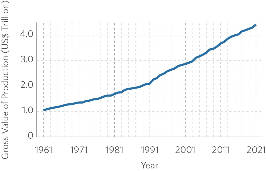
In recent decades, world agricultural production has grown considerably, more than quadrupling in real terms between 1961 and 2021, as shown in Figure 1. Until the 1990s, this growth was accompanied by an expansion in the area occupied by the sector, but since then its main driving force of growth has been through productivity gains. In this way, modern international agriculture is moving towards producing more with less area.
Figure 1. Global Agricultural Production and Area, 1961–2021
1a. Production
1b. Area
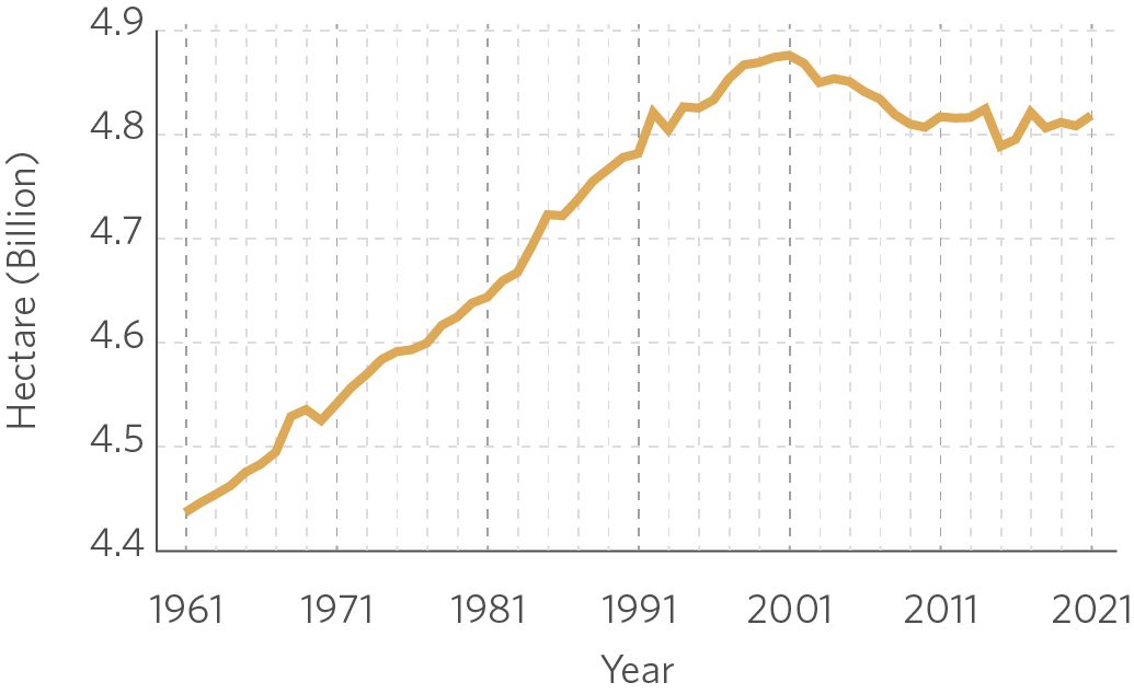
Note: Values at 2016 prices (inflation adjusted by FAOSTAT).
Source: CPI/PUC-RIO with data from FAOSTAT (1961–2021), 2024
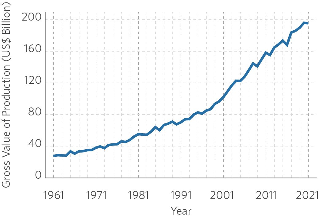
In Brazil, however, the increase in agricultural production continues to be associated with land expansion, as can be seen in Figure 2. The country had a brief period of reversal of this expansion at the end of the 1980s, but this trend stalled in the 2000s and, in more recent years, the area used for agricultural has increased. While the ample availability of already deforested areas makes it possible to double national agricultural production without destroying any more hectares of native vegetation, pressures for deforestation and the clearing of new areas to increase production in the country still exist.[3]
Figure 2. Agricultural Production and Area in Brazil, 1961–2021
2a. Production
2b. Area
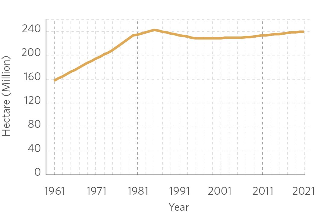
Note: Values at 2016 prices (inflation adjusted by FAOSTAT).
Source: CPI/PUC-RIO with data from FAOSTAT (1961–2021), 2024
To consolidate its leadership in global food production, Brazil needs to keep up with international trends in the modernization and intensification of agriculture. Public policies must direct agriculture towards sustainability, generating incentives to increase production without expanding area and promoting a technological transition to low-carbon agriculture.
The Brazilian Agricultural Plan, the main national policy for the sector, earmarked R$ 436 billion in rural credit for the 2023/24 agricultural year. This amount is equivalent to 38% of the total produced by national agriculture.[4] The loan contracts included in the plan receive tax benefits and can also count on direct subsidies from the federal government, which total more than R$ 13 billion. It is imperative that the public resources directed via the Brazilian Agricultural Plan are dedicated to advancing the modernization of agriculture and environmental preservation.
Rural credit policy has taken significant steps in this direction. The latest editions of the Brazilian Agricultural Plan announced favorable credit conditions for producers with a Rural Environmental Registry (Cadastro Ambiental Rural – CAR) analyzed in accordance with environmental legislation.[5] In addition, credit restriction measures are being implemented, taking into account social, environmental, and climatic factors.[6] For example, properties whose CAR is suspended or canceled or located within an area demarked as a protected area, indigenous land, or quilombola community or has slave labor cannot receive rural credit.
Despite these advances, leveraging rural credit to enhance sustainability and environmental preservation still faces significant challenges. Currently, the only rural credit rule related to deforestation is that it prevents finance for properties with environmental embargoes resulting from illegal suppression of vegetation.[7] However, this measure is limited since less than 5% of new deforestation areas has been embargoed in recent years.[8] A significant portion of the deforested area, therefore, is not restricted and remains eligible for rural credit, including subsidized credit.
Previous CPI/PUC-RIO studies have evaluated the impacts of rural credit on agricultural production and land use.[9] The empirical evidence shows that rural credit, on average, increases crop productivity, intensifying production and relieving deforestation pressures. However, in some cases, credit benefits properties where there is an expansion of the production area, particularly when it comes to larger producers.
In this sense, rural credit policy still needs to be improved to effectively encourage sustainable development and strengthen socio-environmental restrictions. In this way, it can foster modern, low-carbon agriculture and serve as a relevant tool for reducing deforestation.
The Relationship between Rural Credit and Deforestation
To understand the relationship between subsidized rural credit and deforestation, this analysis consolidates information on subsidized rural credit contracts, rural properties, and deforestation data. The data used are from the Rural Credit and PROAGRO Operations System (Sistema de Gestão Fundiária – SICOR) of the Central Bank of Brazil (Banco Central do Brasil – BCB), the National Rural Environmental Registry System (Sistema Nacional de Cadastro Ambiental Rural – SICAR) of the Ministry of Public Management and Innovation (Ministério da Gestão e da Inovação em Serviços Públicos – MGI) and the Program for Monitoring Deforestation in the Legal Amazon by Satellite (Programa de Monitoramento do Desmatamento na Amazônia Legal por Satélite – PRODES) of the National Institute for Space Research (Instituto Nacional de Pesquisas Espaciais – INPE).[10]
This study takes into account deforestation in the PRODES years 2020, 2021, and 2022,[11] superimposing it on the areas of rural properties registered in SICAR to identify those properties with deforestation of more than one hectare.[12] Using the CAR registration number,[13] researchers identify the properties that contracted subsidized rural credit operations in the period.[14]
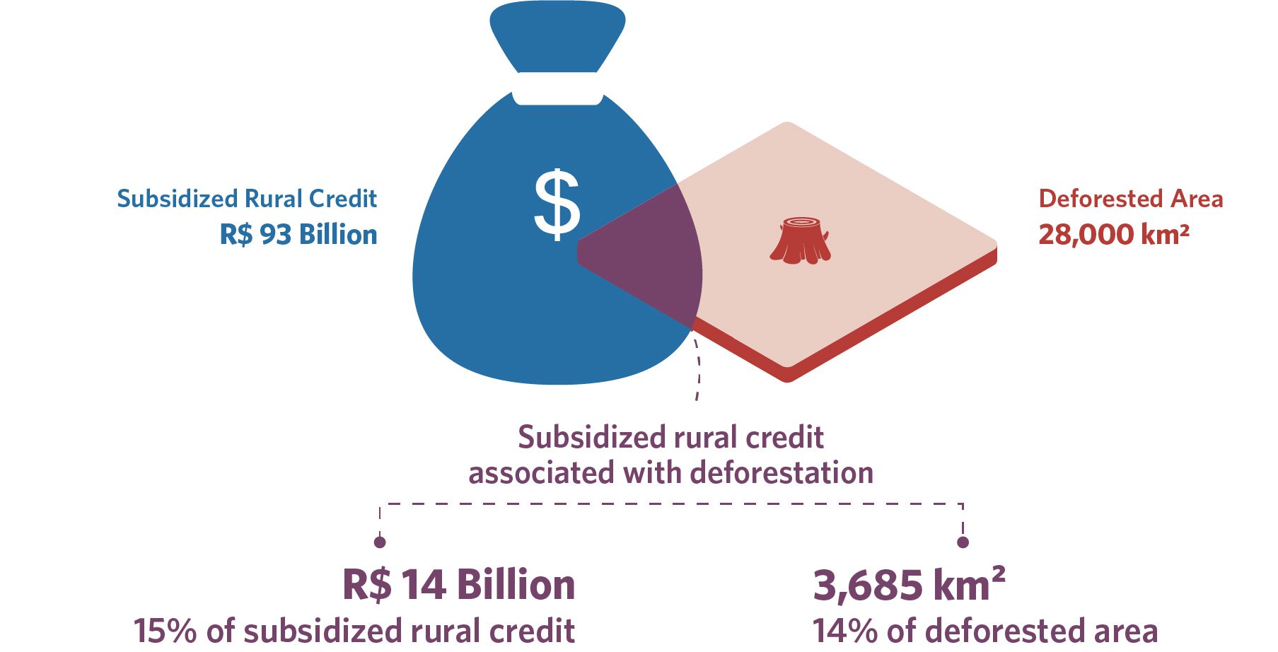
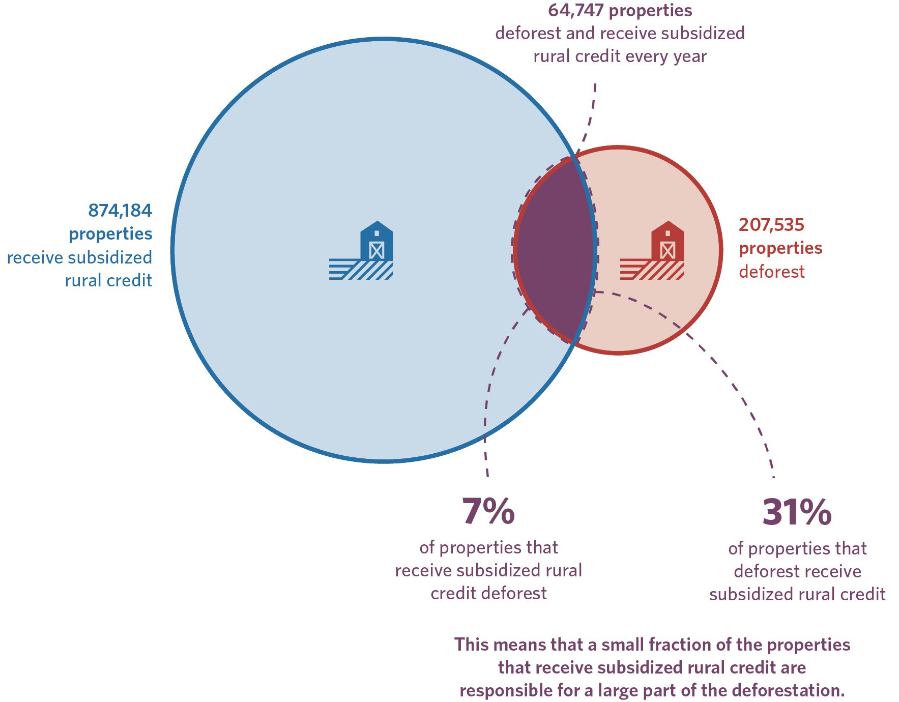
Nearly a third of the properties that deforested between 2020 and 2022 took out subsidized credit during this period, as Figure 3 shows. Annually, financed properties deforested between 3,685 km² and 4,803 km²,[15] representing between 14% and 17% of the total 27,766 km² deforested per year in Brazil.[16] These properties correspond to a significant portion of those that deforest in the country and contribute a significant share of the total national deforested area.[17] By offering subsidies to those who deforest, the current model of rural credit policy fails to discourage further deforestation.
The group of properties with deforestation receives, on average, R$14 billion per year, equivalent to 15% of the resources allocated to subsidized rural credit, which totals R$ 93 billion per year in the period analyzed. However, they represent only 7% of the total number of properties that access these funds. In other words, while they are relatively few in number—around 65,000—these properties absorb a significant amount of resources. Taken together, the results show that a small fraction of the properties that receive subsidized rural credit are responsible for a large part of deforestation.[18]
Figure 3. Relationship between Subsidized Rural Credit and Deforestation, 2020–2022
3a. Volume of Subsidized Rural Credit and Deforested Area, Annual Average
3b. Number of Properties, Annual Average
Source: CPI/PUC-RIO with data from SICOR/BCB (2020–2022), PRODES/INPE (2020–2022), and SICAR (2023), 2024
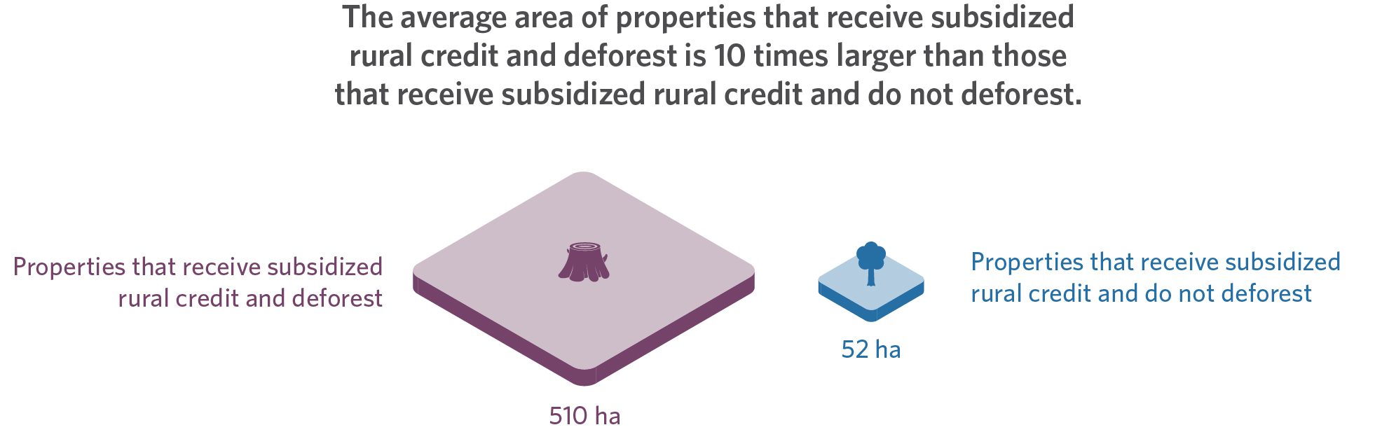
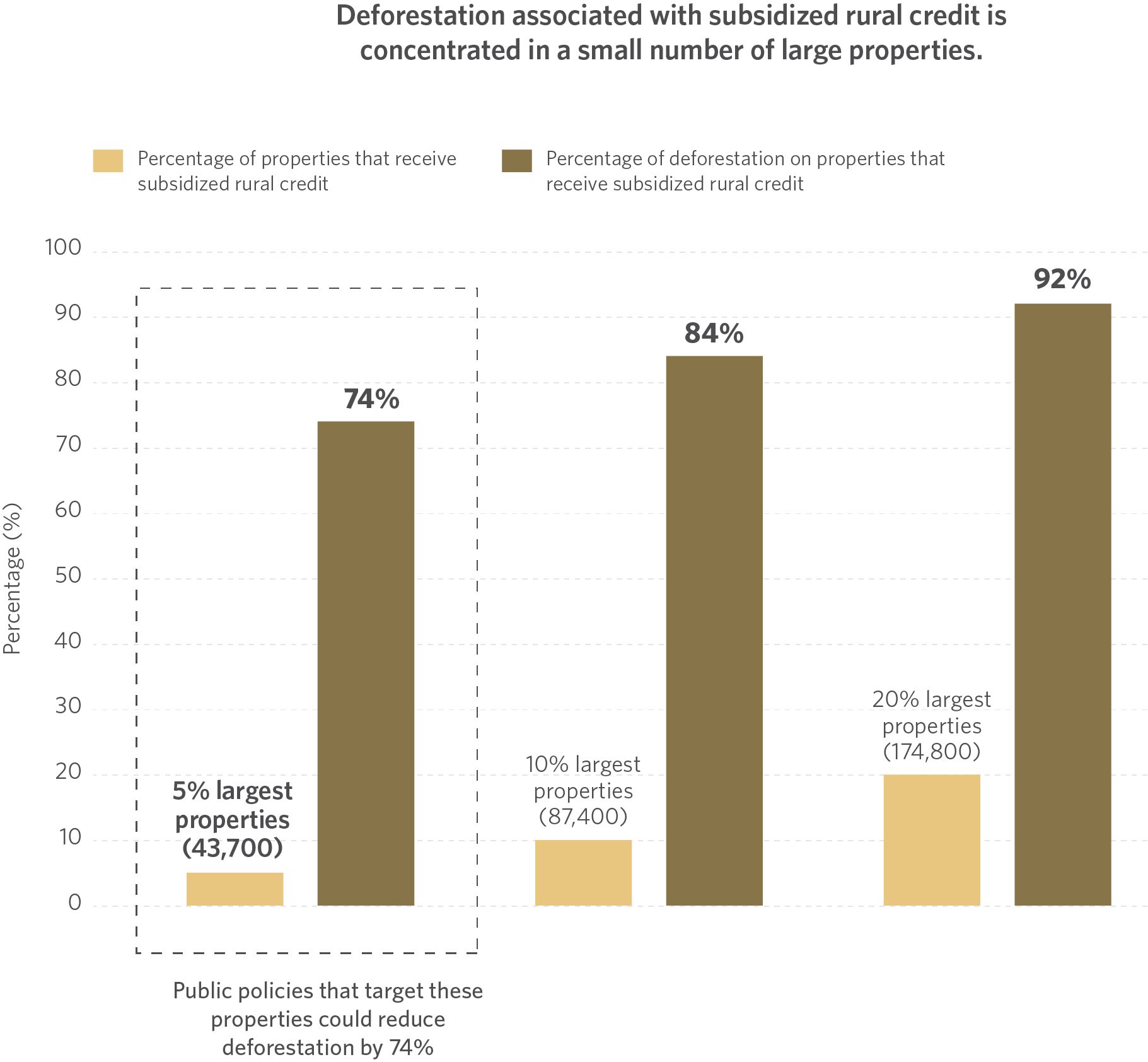
Properties with deforestation that take out subsidized rural credit have, on average, an area almost 10 times larger than properties without deforestation that take out credit, as shown in Figure 4. Deforestation associated with subsidized rural credit is therefore highly concentrated in a small number of large properties. In fact, 5% of the largest properties taking out subsidized rural credit (43,700) account for 74% of the vegetation loss associated with credit. Expanding the number of properties analyzed reveals that 20% of the largest credit-taking properties are responsible for 92% of the group’s deforestation.
Figure 4. Relationship between Deforestation and the Size of Properties that Receive Subsidized Rural Credit in Brazil, 2020–2022
4a. Average Area of Properties that Receive Subsidized Rural Credit, Annual Average
4b. Concentration of Deforestation on Properties that Receive Subsidized Credit, Annual Average
Source: CPI/PUC-RIO with data from SICOR/BCB (2020–2022), PRODES/INPE (2020–2022), and SICAR (2023), 2024
This analysis shows how it is possible to tackle a significant portion of the deforestation promoted by borrowers of subsidized rural credit by focusing efforts to supervise and adhere to environmental standards on a small number of large properties. This strategy will contribute to more effectively align credit policy with the development of sustainable agriculture and the preservation of the country’s environment.
Subsidized Rural Credit and Deforestation by Biome
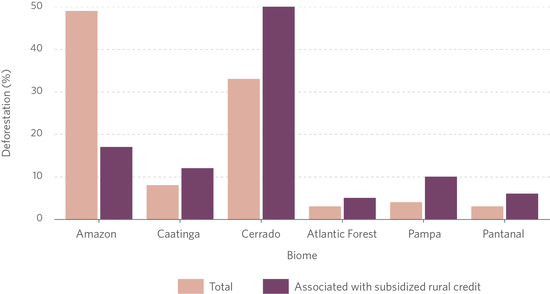
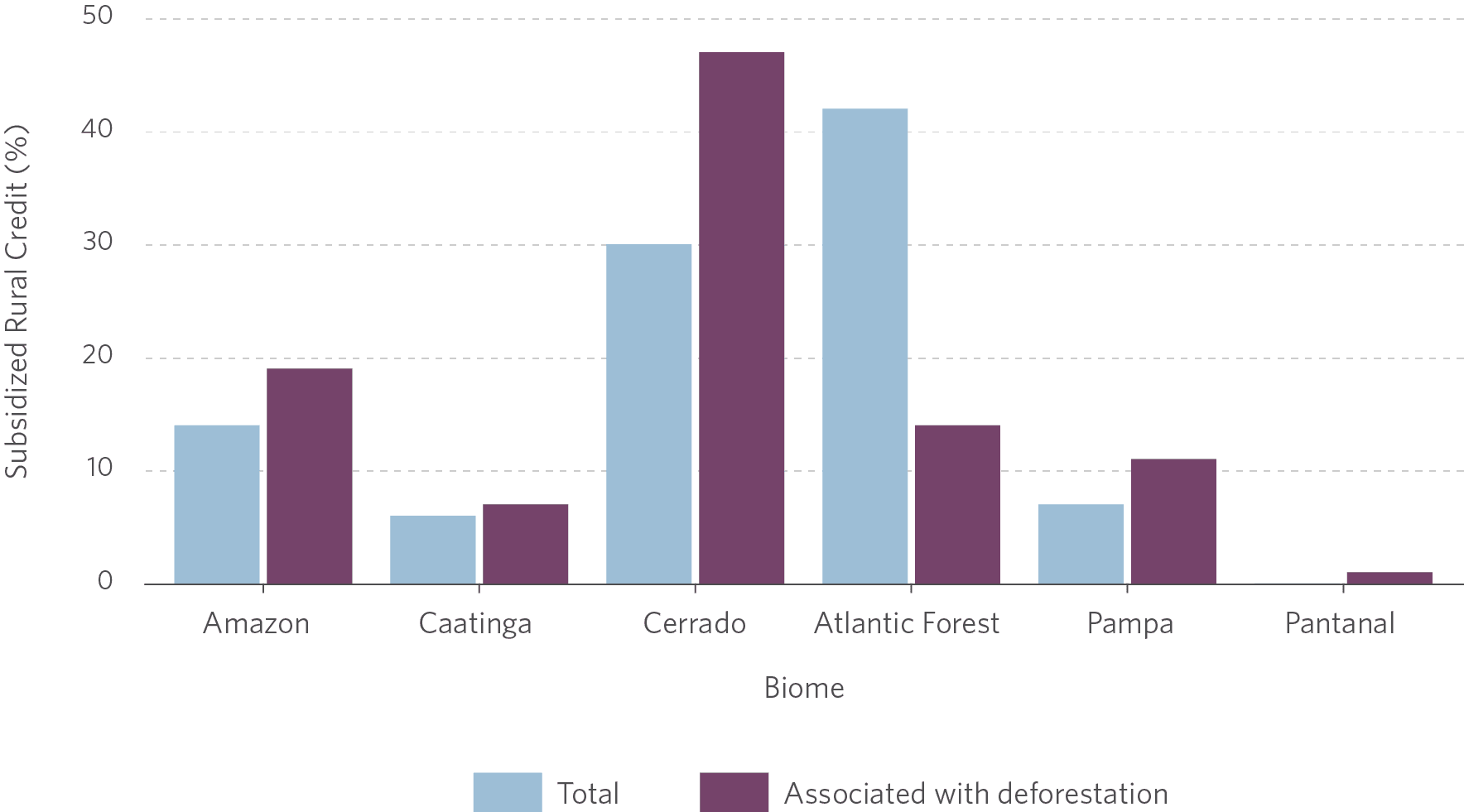
The Cerrado is the biome in which the relationship between subsidized rural credit and deforestation is the strongest, as shown in Figure 5. The Cerrado biome comes in second place in the amount of subsidized rural credit it receives (30%) and as well as in level of deforestation (33%). However, it emerges as the top biome when considering that the majority of subsidized rural credit is associated with deforestation (47%) and where deforestation is associated with subsidized rural credit (50%).
On the other hand, although almost half of the country’s deforestation occurs in the Amazon biome (49%), it accounts for 17% of the deforestation carried out on properties that have accessed subsidized rural credit, receiving 14% of these funds.
Meanwhile, the Atlantic Forest, the biome that most accesses this policy (42%), accounts for the smallest share of deforestation among borrowers of subsidized credit (5%). Thus, this biome accounts for 14% of the volume of resources earmarked for properties with deforestation.
Figure 5. Percentage of Deforestation and Subsidized Credit by Biome, 2020–2022
5a. Deforestation, Annual Average
5b. Subsidized Rural Credit, Annual Average
Source: CPI/PUC-RIO with data from SICOR/BCB (2020–2022), PRODES/INPE (2020–2022), SICAR (2023) and IBGE (2019), 2024
Environmental Embargoes due to Deforestation
Rural credit policy has taken important steps towards sustainability, with the implementation of credit restriction measures that take environmental, social, and climate factors into account.[19] Despite these advances, there are still challenges related to the preservation of native vegetation.
As of January 2, 2024, the rural credit was no longer granted to properties with environmental embargoes due to deforestation in all biomes, a measure that previously applied only to the Amazon.[20] This is currently the only rule restricting rural credit related to deforestation. Thus, some of the properties analyzed in this study are now subject to the new rules and will not be able to access rural credit if they have environmental embargoes in place.
Using data on current embargoes due to deforestation from the Brazilian Institute of Environment and Renewable Natural Resources (Instituto Brasileiro do Meio Ambiente e dos Recursos Naturais – IBAMA), this analysis identifies the properties that would be subject to the credit restriction if it were in force during the period considered (2020–2022). This analysis shows that only 939 properties have environmental embargoes in force due to deforestation out of the annual average of 64,747 properties that deforested and took out subsidized rural credit between 2020 and 2022.
More specifically, the figures found for deforestation associated with subsidized rural credit change little when removing embargoed properties from the results. Of the total deforested area identified, only between 298 km² and 564 km² are on properties with environmental embargoes due to deforestation, leaving between 3,387 km² and 4,239 km² on properties without embargoes. The annual volume of subsidized rural credit granted is only reduced by R$ 435 million when removing embargoes properties, with the remaining R$ 13.6 billion going to properties with deforestation and without embargoes.[21]
This highlights that most of the deforestation identified is not embargoed. Although it is not possible to verify with the data used whether the remaining deforestation on properties that receive subsidized rural credit is authorized or not, this study shows that public resources are being directed to offer differentiated financing conditions for producers who deforest. In this sense, the policy’s economic incentives are not aligned with environmental conservation objectives, since they benefit properties that suppress native vegetation.
Policy Recommendations
This study shows that, annually, 15% of the volume of subsidized rural credit went to properties that deforested between 2020 and 2022. This amount, which leverages significant public resources, is accessed by almost a third of the properties that deforest in the country.
Brazil has the opportunity to correct this misalignment of public policy with the country’s environmental and climate objectives without impacting the majority of rural credit beneficiaries who do not engage in the destruction of native vegetation. The deforestation identified in this analysis is concentrated in large properties: in particular, when granting loans to this group, financial institutions should strengthen their supervision and monitoring efforts.
Land use must be rigorously analyzed, checking for the presence of deforestation and demanding the ASV or equivalent authorization document when vegetation suppression is identified. Some financial institutions, such as the Brazilian Development Bank (Banco Nacional de Desenvolvimento Econômico e Social – BNDES), have already incorporated these efforts and use remote sensing tools to identify and restrict finance to properties with illegal deforestation.[22]
As well as stepping up enforcement against illegal deforestation, the targeting of rural credit subsidies needs to be re-evaluated. Brazil has invested a significant amount of public resources in offering special financing conditions to producers who deforest that could instead be directed towards promoting sustainability in the agricultural sector. To develop modern, low-carbon agriculture, credit subsidies should be directed exclusively to properties without deforestation, regardless of the regularity of vegetation suppression.
Rural credit policy must be improved to encourage gains in land productivity and consider the country’s environmental and climate objectives, complementing efforts to control deforestation.[23] The proper alignment of economic incentives is essential to ensure a sustainable future for the agricultural sector and for the country.
Methodology
This analysis used data on rural credit, rural environmental registers, deforestation, and environmental embargoes due to deforestation in force. The data on rural credit operations were taken from the BCB’s SICOR. Public rural credit microdata were analyzed, which covers operations insured by the Agricultural Activity Guarantee Program (Programa de Garantia da Atividade Agropecuária – PROAGRO) or financed with public sources of funds.
All CARs available on MGI’s SICAR were considered, regardless of status or type.[24]
The deforestation polygons used correspond to the annual PRODES deforestation increments for all of Brazil’s biomes.[25] For this analysis, properties that take out subsidized rural credit and deforest were defined as those associated with at least one rural credit operation with subsidized resources in the period, whose CAR area registered deforestation of more than one hectare at least once during the period analyzed (2020–2022), regardless of when the credit was contracted.[26]
The data on deforestation embargoes was obtained from IBAMA’s spatial information management system within the geoserver.[27] A property was considered embargoed if its area contained[28] georeferenced, in force on May 7, 2024 and issued before August 1, 2022, the last day of the period analyzed.
The period analyzed covers the 2020 to 2022 PRODES years, from August 2019 to July 2022. The interval was selected considering the availability of data from all sources.[29]
Deforestation is reported by PRODES-year and cannot have its period adjusted. Therefore, rural credit operations were allocated to the corresponding PRODES years based on the start date of the operation. Similarly, only current embargoes issued until the end of the last PRODES year in the analysis, 2022, were selected.
The PRODES data ware spatially cross-referenced with the CAR geometries to identify all the properties that overlapped the deforestation polygons. The correspondence between the SICOR data and the CAR database was done using the property code.
Some SICOR operations have more than one associated property (6%). It is not possible to identify the amount of credit associated with each property in these situations. Therefore, if at least one of the properties involved in an operation took credit and had deforestation, the entire operation was considered an operation with deforestation.
It was necessary to create different measures of deforestation, since the CAR is self-declared and few registrations have been validated by authorities, resulting in polygons with overlaps between them. In these cases, the deforested area was allocated to just one CAR to avoid double counting of deforestation that intersects two or more CARs. As a result, three measures of deforestation were created: (i) number of properties associated with deforestation; (ii) lower limit of the area associated with deforestation; and (iii) upper limit of the area associated with deforestation.
The first measure consists of simply identifying properties that deforest, mapping all CARs that intersect with a deforestation polygon, regardless of overlapping geometries. This measure does not discard any registrations initially, allowing all properties that have taken credit and had deforestation to be identified in the subsequent cross-referencing with SICOR. To ensure greater precision and avoid measurement errors at this stage, all CAR and deforestation intersections of less than one hectare were discarded.
The other measures consist of estimating the total deforested area associated with the CARs, using criteria to clear overlaps and avoid double counting of deforestation. The criteria for clearing overlaps considers whether or not rural credit had been taken out, the type of property, and the CAR area, in the following order of priority:
- CARs that have taken/not taken credit;
- CAR of the rural property type (IRU); and
- CAR with the smallest/largest area.
Following the order established for these criteria, the deforestation polygon overlapping more than one CAR was allocated to only one registry. The combined criteria resulted in two final measures of deforestation area:
1. Lower bound of the deforested area associated with credit:
In a possible overlap of deforested area between a CAR that has taken credit and another that has not, the deforested area has been allocated to the CAR that has not taken credit. In the case of both properties taking or not taking credit, the deforestation is then allocated to the rural property type (IRU). If both CARs are of the same type, the deforestation is then allocated to the CAR with the largest area. The same exercise was repeated analogously with the tie-breaking criterion applied to the CAR with the smallest area. To obtain the lower limit, the minimum value between the two measures generated was taken. The example only considers overlap between two CARs, but the criterion applies to the allocation of the deforested area between two or more CARs with overlapping areas.
2. Upper bound of the deforested area associated with credit:
The deforested area is allocated to the CAR that took credit. In the case of both properties taking or not taking credit, the deforestation is then allocated to the CAR of the rural property type (IRU). If both CARs are of the same type, the deforestation is attributed to the CAR with the largest area. The same exercise was repeated with the tie-breaking criterion applied to the CAR with the smallest area. To obtain the upper limit, the maximum value between the two measures generated was taken. The example only considers overlap between two CARs, but the criterion applies to the allocation of the deforested area between two or more CARs with overlapping areas.
The lower bound provides a minimum measure of deforested area associated with properties that have taken credit, while the upper bound provides a maximum measure of deforested area associated with properties that have taken credit. From the two estimated measures, a range of deforested area associated with credit is obtained.
The authors would like to thank Marcelo Sessim and Rogério Reis for their excellent research assistance; Wagner Oliveira, Natalie Hoover El Rashidy, Juliano Assunção, Cristina Leme Lopes, Joana Chiavari, and Giovanna de Miranda for their comments and suggestions. We would also like to thank Camila Calado for proofreading and editing the text and Meyrele Nascimento for the graphic design work.
[1] Learn more at: Antonaccio, Luiza et. al. Ensuring Greener Economic Growth for Brazil. Rio de Janeiro: Climate Policy Initiative, 2018. bit.ly/GreenerEconomic.
[2] To carry out this analysis, geospatial deforestation data from the Program for Monitoring Deforestation in the Legal Amazon by Satellite (Programa de Monitoramento do Desmatamento na Amazônia Legal por Satélite – PRODES) of the National Institute for Space Research (Instituto Nacional de Pesquisas Espaciais – INPE) was combined with data from the National Rural Environmental Registry System (Sistema Nacional de Cadastro Ambiental – SICAR) and information on rural credit operations from the Central Bank of Brazil (Banco Central do Brasil – BCB).
[3] Antonaccio, Luiza et al. Ensuring Greener Economic Growth for Brazil. Rio de Janeiro: Climate Policy Initiative, 2018. bit.ly/GreenerEconomic.
[4] MAPA. Valor Bruto da Produção atinge R$ 1,151 trilhão em 2023. 2023. bit.ly/4eydltJ.
[5] CMN Resolution no. 4,883/2020, December 23, 2020. bit.ly/CMN4883.
CMN Resolution no. 5,021/2022, June 29, 2022. bit.ly/CMN5021.
CMN Resolution no. 5,078/2023, June 29, 2023. bit.ly/CMN5078.
CMN Resolution no. 5,102/2023, August 24, 2023. bit.ly/CMN5102.
[6] BCB Resolution no. 140/2021, September 15, 2021. bit.ly/CMN140.
CMN Resolution no. 5,081/2023, June 29, 2023. bit.ly/CMN5081.
[7] CMN Resolution no. 5,081/2023, June 29, 2023. bit.ly/CMN5081.
[8] Calculated using data from environmental embargoes for deforestation from the Brazilian Institute for the Environment and Natural Resources (Instituto Brasileiro do Meio Ambiente e Recursos Naturais – IBAMA) and PRODES deforestation for the years 2020 to 2022. As of the date of this publication, PRODES had not yet released deforestation data for 2023. However, the area embargoed in 2023 doubled in size compared to the previous year, while deforestation in the Amazon and Cerrado fell significantly.
[9] Souza, Priscila, Stela Herschmann, and Juliano Assunção. Rural Credit Policy in Brazil: Agriculture, Environmental Protection and Economic Development. Rio de Janeiro: Climate Policy Initiative, 2020. bit.ly/RuralCredit.
[10] Detailed information about the data can be found in the methodology section of this publication.
[11] The PRODES year refers to the period between August of the previous year and July of the reference year. For the period in question, the window analyzed corresponds to August 2019 to July 2022.
[12] For the purposes of this study, a property is said to have deforested if at least one episode of deforestation of more than 1 hectare was recorded in its area between the PRODES years 2020 and 2022.
[13] The CAR is a mandatory electronic registry for rural properties, which aims to integrate and standardize all environmental information on rural properties and possessions.
[14] A property is said to have received subsidized rural credit if its CAR was registered as a subsidized rural credit borrower between the PRODES years 2020 and 2022.
[15] The CAR is a self-declaratory registry, and, as of November 2023, only 2.7% of the country’s registrations had been analyzed by the competent bodies. As a result, SICAR’s database shows several overlaps between registered properties. To avoid double counting the deforested areas in cases where there are overlapping registrations, the deforestation identified was allocated to just one CAR using two different criteria, one more and one less conservative, detailed in the Methodology section of this publication. Learn more at: Lopes, Cristina L., Maria Eduarda Segovia, and Joana Chiavari. Where Does Brazil Stand with the Implementation of the Forest Code? A Snapshot of CAR and PRA in Brazilian States – 2023 Edition. Rio de Janeiro: Climate Policy Initiative, 2023. bit.ly/WhereDoesBrazil-2023.
[16] Similarly, deforestation associated with this group of properties corresponds to between 16 and 21% of deforestation in CAR areas.
[17] Most of the deforestation on properties that received subsidized credit occurred in the Cerrado biome. For more details on the results by biome, see the box “Subsidized Rural Credit and Deforestation by Biome” in this publication.
[18] Some of the properties with deforestation that accessed subsidized rural credit between 2020 and 2022 would not be able to do so today due to new regulations imposed by the BCB. However, even if the current rules were in force during the period analyzed, the results presented in this publication would not be substantially altered. For more details, see the section on environmental embargoes for deforestation in this publication.
[19] The restrictions apply to both subsidized and unsubsidized rural credit. See BCB Resolution no. 140/2021, September 15, 2021. bit.ly/CMN140.
[20] CMN Resolution no. 5,081/2023, June 29, 2023. bit.ly/CMN5081.
[21] In addition, there are still R$ 387 million a year in subsidized rural credit granted to properties with environmental embargoes in force and no deforestation in the period under analysis that are subject to the new restriction measure.
[22] BNDES. SUP/ADIG Circular no. 57/2022-BNDES, November 11, 2022. 2022. bit.ly/CircularSUPADIG. Access date: May 23, 2023.
[23] Antonaccio, Luiza, Cristina L. Lopes, and Eduardo Minsky. The (Lack of) Control of Legal Deforestation in MATOPIBA: Regulation and Governance of Authorizations for the Suppression of Vegetation. Rio de Janeiro: Climate Policy Initiative, 2024. bit.ly/DeforestationInMatopiba.
[24] CARs are classified into three types: Rural Property (Imóvel Rural – IRU), Settlement (Assentamento – AST) and Traditional Community Peoples (Povos e Comunidades Tradicionais – PCT).
[25] The polygons used were of vegetation suppression of an area greater than 1 hectare in all biomes. In order to do this, data on the annual increase in deforestation in all biomes was used. For the Amazon, deforestation in non-forest areas was also considered.
[26] Thus, properties that take out subsidized rural credit and deforest are either properties that deforested before taking out the credit or afterwards.
[27] The base is identified on the portal as “vwm_adm_embargo_ativo_a”. Learn more at: Ibama. Geoserver. bit.ly/3VCtHZI.
[28] An embargo was classified as “due to deforestation” if the “sit_deforestation” variable was filled in with a “D”.
[29] At the time of writing, the last year in which PRODES was available for all biomes was 2022. On the credit side, filling in the CAR registration number has only been required in SICOR since 2019, with 2020 being the first year in which this information is complete.
